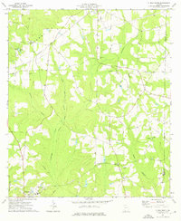
1974 Map of Climax South
USGS Topo · Published 1976About this map
Attapulgus and Climax anchor the southern and northern reaches of this mid-1970s survey of Decatur County, Georgia. The landscape is defined by the Seaboard Coast Line railroad and a network of watercourses including Attapulgus Creek, Walker Branch, and Yellow Water Branch. This area is particularly rich in family and community history, evidenced by a high density of rural religious and burial sites. Genealogists can find the Samuel Cem, Conyers Cem, and Butler Cem, alongside numerous churches like Mt Moriah Ch No 1 and Mt Moriah Ch No 2. The topography rises toward Curry Hill in the northwest, while a prominent pipeline and the county boundary with Grady County provide additional geographic context for researchers studying land use and development patterns in this South Georgia region.
Find a feature on this map
26 named features on this map. Tap any name to fly to it.
Don’t see what you’re looking for? This feature index may not catch every label — zoom into the map to look around manually.
Map Details
Editions of this 1974 Climax South Map
This is the sole edition of this map. No revisions or reprints were ever made.
Other maps of this area

1954 · Tallahassee
USGS Topo · 1:250,000

1955 · Bainbridge
USGS Topo · 1:62,500

1955 · Whigham
USGS Topo · 1:62,500

1956 · Havana North
USGS Topo · 1:24,000

1956 · Dogtown
USGS Topo · 1:24,000

1956 · Calvary
USGS Topo · 1:24,000

1959 · Tallahassee
USGS Topo · 1:250,000

1960 · Tallahassee
USGS Topo · 1:250,000
1974 · Bainbridge
USGS Topo · 1:24,000
1974 · Fowlstown
USGS Topo · 1:24,000