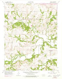
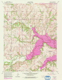
1955 Map of Clinton
USGS Topo · Published 1978About this map
Stull and Clinton anchor this mid-century view of the Douglas County countryside, where the winding Wakarusa River defines the southern landscape. The map captures a moment of transition for the region, showing the modern path of the Kansas Turnpike cutting through the northern corner while rural life remains centered around established community hubs. Local education and memory are preserved in the locations of Deer Creek Sch, Yarnold Sch, and Belvoir Sch, alongside the prominent Mound Cem and Clinton Cem. The drainage patterns of Deer Creek, Dry Creek, and Coon Creek illustrate the natural topography before the construction of major local reservoirs. These agricultural lands, divided by the townships of Kanwaka and Clinton, reflect the enduring settlement patterns of eastern Kansas just prior to significant suburban expansion.
Find a feature on this map
22 named features on this map. Tap any name to fly to it.
Don’t see what you’re looking for? This feature index may not catch every label — zoom into the map to look around manually.
Map Details
Editions of this 1955 Clinton Map
5 editions found
Other maps of this area

1885 · Lawrence
USGS Topo · 1:125,000

1886 · Oskaloosa
USGS Topo · 1:125,000

1888 · Oskaloosa
USGS Topo · 1:125,000

1889 · Burlingame
USGS Topo · 1:125,000

1889 · Topeka
USGS Topo · 1:125,000

1889 · Lawrence
USGS Topo · 1:125,000

1894 · Burlingame
USGS Topo · 1:125,000

1894 · Oskaloosa
USGS Topo · 1:125,000

1894 · Topeka
USGS Topo · 1:125,000

1947 · Lawrence
USGS Topo · 1:250,000