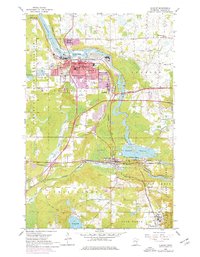
1954 Map of Cloquet
USGS Topo · Published 1976About this map
The St Louis River carves through this Carlton County landscape, driving the industrial and residential growth of Cloquet and Scanlon. The 1950s infrastructure is dominated by the Burlington Northern and Duluth and Northeastern railroads, which service the local economy near Knife Falls. Purple revision overlays from the mid-1970s illustrate the expansion of Cloquet’s urban footprint, particularly around Jefferson Sch and Pinehurst Park. To the south, the village of Carlton sits near the Thomson Reservoir, a focal point for water management and transit. This map provides a detailed view of social centers, from the Fond du Lac Hospital to numerous local congregations like Holy Family Ch and St Mathews Ch. The southern reaches transition into the preserved lands of Jay Cooke State Park and Thomson Lakes State Park, where the Midway River and Silver Creek flow through more secluded terrain.
Find a feature on this map
51 named features on this map. Tap any name to fly to it.
Don’t see what you’re looking for? This feature index may not catch every label — zoom into the map to look around manually.
Map Details
Editions of this 1954 Cloquet Map
5 editions found
Other maps of this area

1953 · Saginaw
USGS Topo · 1:24,000

1953 · Adolph
USGS Topo · 1:24,000

1953 · Brookston
USGS Topo · 1:24,000

1953 · Duluth
USGS Topo · 1:250,000

1954 · Cloquet
USGS Topo · 1:24,000

1954 · Wrenshall
USGS Topo · 1:24,000

1954 · Frogner
USGS Topo · 1:24,000

1954 · Atkinson
USGS Topo · 1:24,000

1954 · Esko
USGS Topo · 1:24,000

1954 · Iverson
USGS Topo · 1:24,000