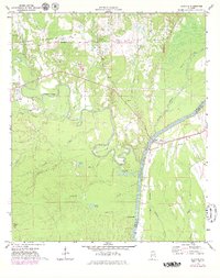
1971 Map of Coatopa
USGS Topo · Published 1979About this map
The Tombigbee River snakes along the eastern edge of this landscape, meeting the winding Sucarnoochee River in a complex network of wetlands and oxbows. In the 1970s, this area of Sumter County was defined by its water-bound geography and small settlements like Coatopa and Bellamy. Evidence of earlier transport persists in the Old Railroad Grade running through the northern sections, while the presence of Rooster Bridge marks a critical river crossing near Moscow.
Find a feature on this map
35 named features on this map. Tap any name to fly to it.
Don’t see what you’re looking for? This feature index may not catch every label — zoom into the map to look around manually.
Map Details
Editions of this 1971 Coatopa Map
4 editions found

Other maps of this area

1929 · Epes
USGS Topo · 1:48,000

1932 · Epes
USGS Topo · 1:62,500

1948 · Mc Dowell
USGS Topo · 1:24,000

1949 · Mc Dowell
USGS Topo · 1:24,000

1953 · Montgomery
USGS Topo · 1:250,000

1953 · Meridian
USGS Topo · 1:250,000

1956 · Montgomery
USGS Topo · 1:250,000

1957 · Meridian
USGS Topo · 1:250,000

1957 · Montgomery
USGS Topo · 1:250,000

1965 · Meridian
USGS Topo · 1:250,000