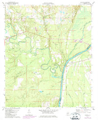
1971 Map of Coatopa
USGS Topo · Published 1987About this map
The Sucarnoochee River winds through the West Alabama timberlands before meeting the broader Tombigbee River, which defines the border between Sumter and Marengo counties. This 1971 study, updated with mid-1980s data, reveals a rural landscape dominated by the winding paths of Ponkabia Creek, Mill Creek, and Soctum Creek. The settlement at Bellamy and the village of Coatopa serve as local anchors, connected by a road network that crosses an Old Railroad Grade north of town. Along the riverbanks, river-dependent history is evident at Chaney Landing and Deans Landing, while the presence of Marys Chapel Cem, Mt Tabor Ch, and Friendship Ch provides essential data points for family historians researching the congregations and communities of this river valley.
Find a feature on this map
35 named features on this map. Tap any name to fly to it.
Don’t see what you’re looking for? This feature index may not catch every label — zoom into the map to look around manually.
Map Details
Editions of this 1971 Coatopa Map
4 editions found

Other maps of this area

1929 · Epes
USGS Topo · 1:48,000

1932 · Epes
USGS Topo · 1:62,500

1948 · Mc Dowell
USGS Topo · 1:24,000

1949 · Mc Dowell
USGS Topo · 1:24,000

1953 · Montgomery
USGS Topo · 1:250,000

1953 · Meridian
USGS Topo · 1:250,000

1956 · Montgomery
USGS Topo · 1:250,000

1957 · Meridian
USGS Topo · 1:250,000

1957 · Montgomery
USGS Topo · 1:250,000

1965 · Meridian
USGS Topo · 1:250,000