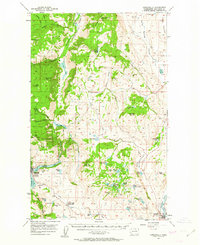
1957 Map of Conconully
USGS Topo · Published 1963About this map
The mountain town of Conconully serves as a central hub in this mid-century survey of Okanogan County, where the transition from high-desert coulees to the timbered peaks of the Okanogan National Forest is clearly defined. The irrigation and water management patterns of the era are visible through the proximity of Conconully Lake and Fish Lake, supporting the ranching and agricultural lands of the lower elevations. Local civic life is anchored by landmarks such as the Beeman School and the Scotch Creek Grange Hall, while the northern reaches reflect a legacy of resource extraction at the Silver Mtn Mine. In the east, the Great Northern railroad follows the Okanogan River through Riverside, connecting this isolated mountain region to broader markets. The preservation of the landscape is noted by the extensive Sinlahekin Game Range, which spans much of the Sinlahekin Creek valley.
Find a feature on this map
61 named features on this map. Tap any name to fly to it.
Don’t see what you’re looking for? This feature index may not catch every label — zoom into the map to look around manually.
Map Details
Editions of this 1957 Conconully Map
3 editions found

Other maps of this area

1902 · Osoyoos
USGS Topo · 1:125,000

1904 · Osoyoos
USGS Topo · 1:125,000

1905 · Okanogan
USGS Topo · 1:125,000

1906 · Chopaka
USGS Topo · 1:125,000

1953 · Omak Lake
USGS Topo · 1:62,500

1954 · Okanogan
USGS Topo · 1:250,000

1956 · Loup Loup
USGS Topo · 1:62,500

1956 · Loomis
USGS Topo · 1:62,500

1956 · Tiffany Mountain
USGS Topo · 1:62,500

1956 · Horseshoe Basin
USGS Topo · 1:62,500