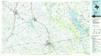
1985 Map of Corsicana
USGS Topo · Published 1986About this map
The Trinity River valley and its surrounding Blackland Prairie terrain anchor this mid-1980s look at North Central Texas. The landscape is defined by its water infrastructure and agricultural roots, featuring major impoundments like the massive Cedar Creek Reservoir and the smaller Bardwell Lake controlled by the Bardwell Dam. Educational and religious institutions are prominent landmarks, including Navarro College in Corsicana and the Southwestern Bible Institute near Waxahachie. The map documents a transition in rural life, where long-established communities like Rice and Italy are linked by a maturing highway system including I-45 and Us 287.
Find a feature on this map
170 named features on this map. Tap any name to fly to it.
Don’t see what you’re looking for? This feature index may not catch every label — zoom into the map to look around manually.
Map Details
Editions of this 1985 Corsicana Map
2 editions found
Other maps of this area

1891 · Dallas
USGS Topo · 1:125,000

1891 · Cleburne
USGS Topo · 1:125,000

1892 · Waco
USGS Topo · 1:125,000

1893 · Dallas
USGS Topo · 1:125,000

1894 · Cleburne
USGS Topo · 1:125,000

1894 · Fort Worth
USGS Topo · 1:125,000

1920 · Waco
USGS Topo · 1:125,000

1920 · Kemp
USGS Topo · 1:62,500

1948 · Martins Mill
USGS Topo · 1:62,500

1949 · Martins Mill
USGS Topo · 1:62,500