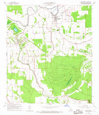
1966 Map of Cottonport
USGS Topo · Published 1967About this map
The town of Cottonport sits at the center of this 1960s survey, showing its connection to the Texas and Pacific railroad and a network of bayous that define the Avoyelles Parish landscape. The settlement of Evergreen to the southwest and smaller points like Karo and Goudeau are surrounded by a complex system of waterways, including Bayou Rouge, Huffpower Bayou, and Indian Bayou. The density of rural institutions is notable, with local congregations at Jerusalem Ch, St Johns Ch, and Golden Chain Ch marking the social hubs of the era.
Find a feature on this map
34 named features on this map. Tap any name to fly to it.
Don’t see what you’re looking for? This feature index may not catch every label — zoom into the map to look around manually.
Map Details
Editions of this 1966 Cottonport Map
3 editions found
Other maps of this area

1940 · Marksville
USGS Topo · 1:62,500

1941 · Voorhies
USGS Topo · 1:62,500

1948 · Bunkie
USGS Topo · 1:62,500

1952 · Lake Charles
USGS Topo · 1:250,000

1953 · Alexandria
USGS Topo · 1:250,000

1953 · Natchez
USGS Topo · 1:250,000

1954 · Lake Charles
USGS Topo · 1:250,000

1954 · Baton Rouge
USGS Topo · 1:250,000

1955 · Odenburg
USGS Topo · 1:62,500

1955 · Alexandria
USGS Topo · 1:250,000