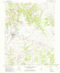
1965 Map of Coulterville
USGS Topo · Published 1982About this map
Coulterville serves as the primary hub of this 1960s landscape, situated at the busy intersection of the Missouri Pacific and the I C G railroads. The map captures a transition in the local economy, where the expansive agricultural lands of the Grande Cote Prairie meet industrial markers like a Pit and a prominent Radio Tower. The rural character of the region is defined by the winding paths of Mud Creek and Galum Creek, alongside small settlements such as Swanwick and McKinley.
Find a feature on this map
23 named features on this map. Tap any name to fly to it.
Don’t see what you’re looking for? This feature index may not catch every label — zoom into the map to look around manually.
Map Details
Editions of this 1965 Coulterville Map
2 editions found
Other maps of this area

1910 · Okawville
USGS Topo · 1:62,500

1914 · Coulterville
USGS Topo · 1:62,500

1917 · Coulterville
USGS Topo · 1:62,500

1924 · Pinckneyville
USGS Topo · 1:62,500

1926 · Pinckneyville
USGS Topo · 1:62,500

1931 · Hoyleton
USGS Topo · 1:48,000

1932 · Nashville
USGS Topo · 1:62,500

1936 · Nashville
USGS Topo · 1:62,500

1940 · Okawville
USGS Topo · 1:62,500

1958 · Belleville
USGS Topo · 1:250,000