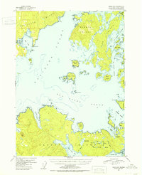
1951 Map of Craig D-5
USGS Topo · Published 1953About this map
Kosciusko Island and Heceta Island dominate this coastal survey, where the intricate waterways of Sea Otter Sound and Davidson Inlet reveal a landscape defined by 1950s maritime and industrial activity. Near the settlement of Edna Bay, a Mine and the small outpost of Alcoa signify the early resource extraction efforts in the region. Further east, on the southern shore of Heceta Island, the presence of a Lumber Camp (Abandoned) near Tonowek Bay speaks to the transient nature of the timber industry during this era. The interior of the islands is dotted with freshwater systems like Chuck Lake, Island Lake, and Mink Lake, while the eastern margins are carved by the narrow channels of El Capitan Passage and Karheen Passage, essential routes for local navigation between the numerous smaller islands such as Owl Island and Eagle Island.
Find a feature on this map
64 named features on this map. Tap any name to fly to it.
Don’t see what you’re looking for? This feature index may not catch every label — zoom into the map to look around manually.
Map Details
Editions of this 1951 Craig D-5 Map
5 editions found
Other maps of this area

1948 · Petersburg A-6
USGS Topo · 1:63,360

1949 · Craig D-4
USGS Topo · 1:63,360

1949 · Petersburg A-5
USGS Topo · 1:63,360

1949 · Petersburg A-4
USGS Topo · 1:63,360

1949 · Craig C-4
USGS Topo · 1:63,360

1951 · Craig C-6
USGS Topo · 1:63,360

1951 · Craig D-6
USGS Topo · 1:63,360

1951 · Craig C-4
USGS Topo · 1:63,360

1951 · Craig C-5
USGS Topo · 1:63,360

1951 · Craig D-5
USGS Topo · 1:63,360