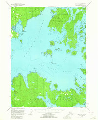
1951 Map of Craig D-5
USGS Topo · Published 1964About this map
The complex archipelago of the Alexander Archipelago is charted here in the early 1950s, centered on the deep waterways of Davidson Inlet and Otter Sound. Coastal activity is marked by the presence of Edna Bay on the southern shore of Kosciusko Island and the maritime infrastructure supporting the region's timber and quarrying history. Evidence of shifting industrial footprints appears at Tokeen (Aban'd) on the northern edge and a Lumber Camp (Abandoned) on the eastern side of Heceta Island.
Find a feature on this map
50 named features on this map. Tap any name to fly to it.
Don’t see what you’re looking for? This feature index may not catch every label — zoom into the map to look around manually.
Map Details
Editions of this 1951 Craig D-5 Map
5 editions found
Other maps of this area

1948 · Petersburg A-6
USGS Topo · 1:63,360

1949 · Craig D-4
USGS Topo · 1:63,360

1949 · Petersburg A-5
USGS Topo · 1:63,360

1949 · Petersburg A-4
USGS Topo · 1:63,360

1949 · Craig C-4
USGS Topo · 1:63,360

1951 · Craig C-6
USGS Topo · 1:63,360

1951 · Craig D-6
USGS Topo · 1:63,360

1951 · Craig C-4
USGS Topo · 1:63,360

1951 · Craig C-5
USGS Topo · 1:63,360

1951 · Craig D-5
USGS Topo · 1:63,360