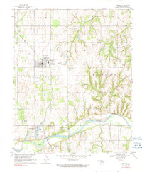
1970 Map of Crescent
USGS Topo · Published 1991About this map
Crescent serves as the focal point of this Logan County landscape, situated where the Atchison Topeka and Santa Fe railroad crosses the rolling terrain north of the Cimarron River. The map reveals a community deeply integrated with the energy industry of the early 1970s, surrounded by the Northeast Crescent Oil Field, East Lovell Oil Field, and West Lawrie Oil Field. These industrial zones are balanced by local landmarks such as St Margaret Mary Ch and Central Ch, which anchor the town’s social fabric.
Find a feature on this map
31 named features on this map. Tap any name to fly to it.
Don’t see what you’re looking for? This feature index may not catch every label — zoom into the map to look around manually.
Map Details
Editions of this 1970 Crescent Map
2 editions found
Other maps of this area

1892 · Guthrie
USGS Topo · 1:62,500

1892 · Kingfisher
USGS Topo · 1:125,000

1893 · Mulhall
USGS Topo · 1:62,500

1893 · Lovell
USGS Topo · 1:62,500

1895 · Kingfisher
USGS Topo · 1:125,000

1954 · Oklahoma City
USGS Topo · 1:250,000

1955 · Enid
USGS Topo · 1:250,000

1957 · Oklahoma City
USGS Topo · 1:250,000

1958 · Enid
USGS Topo · 1:250,000

1963 · Oklahoma City
USGS Topo · 1:250,000