
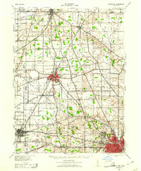
1943 Map of Crestline
USGS Topo · Published 1943About this map
The heavy rail infrastructure of the Pennsylvania and Erie lines defines this mid-century landscape where Crawford, Huron, and Richland counties meet. Crestline and Shelby emerge as the primary industrial and transport hubs, linked by a dense network of steam-era tracks including the Baltimore And Ohio. Beyond the larger towns, the rural character of the Connecticut Reserve remains evident in the systematic placement of dozens of numbered schoolhouses, such as School No 10 and School No 12, and vanished stops like Planktown and Ganges. The transition toward modern aviation is visible in the presence of Mansfield Airport and the smaller Gages Airport, while the industrial footprint of the era is marked by the Power Station and Pump Station facilities near the major rail junctions.
Find a feature on this map
78 named features on this map. Tap any name to fly to it.
Don’t see what you’re looking for? This feature index may not catch every label — zoom into the map to look around manually.
Map Details
Editions of this 1943 Crestline Map
2 editions found
Other maps of this area

1908 · Ashland
USGS Topo · 1:62,500

1908 · New London
USGS Topo · 1:62,500

1912 · Perrysville
USGS Topo · 1:62,500

1913 · Mount Gilead
USGS Topo · 1:62,500

1915 · Norwalk
USGS Topo · 1:62,500

1915 · Siam
USGS Topo · 1:62,500

1915 · Bucyrus
USGS Topo · 1:62,500

1915 · Crestline
USGS Topo · 1:62,500

1915 · Perrysville
USGS Topo · 1:62,500

1915 · Shauck
USGS Topo · 1:62,500