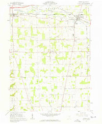
1961 Map of Creston
USGS Topo · Published 1962About this map
Creston stands as a significant rail hub at the intersection of the Erie-Lackawanna, Baltimore And Ohio, and New York Chicago And ST Louis railroads. This early 1960s landscape in Wayne and Medina counties reveals a rural society structured around small crossroads settlements like West Canaan, Hermanville, and Golden Corners. The map clearly delineates the Connecticut Western Reserve boundary, reflecting the region's unique land survey history. Numerous gas wells are scattered across the terrain, indicating the importance of local energy extraction during this period.
Find a feature on this map
37 named features on this map. Tap any name to fly to it.
Don’t see what you’re looking for? This feature index may not catch every label — zoom into the map to look around manually.
Map Details
Editions of this 1961 Creston Map
3 editions found
Other maps of this area

1901 · Wooster
USGS Topo · 1:62,500

1903 · Wooster
USGS Topo · 1:62,500

1904 · Medina
USGS Topo · 1:62,500

1904 · Wellington
USGS Topo · 1:62,500

1906 · Medina
USGS Topo · 1:62,500

1906 · Wellington
USGS Topo · 1:62,500

1906 · West Salem
USGS Topo · 1:62,500

1908 · West Salem
USGS Topo · 1:62,500

1950 · Cleveland
USGS Topo · 1:250,000

1950 · Marion
USGS Topo · 1:250,000