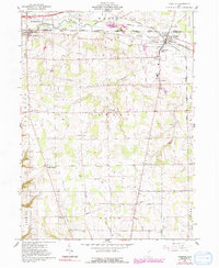
1961 Map of Creston
USGS Topo · Published 1991About this map
The village of Creston and the township of Canaan define this northern Ohio landscape during the early 1960s, a period marked by established rail corridors and agricultural sprawl. The confluence of the Erie Lackawanna and Norfolk and Western railroads through Creston highlights the area's importance as a transportation hub. A distinct social landscape is visible through the presence of the County Home for the Aged and a network of small, rural settlements like Burbank, Jackson, and Hermanville. Numerous family and community burial sites, including Cupps Cem, Maple Mound Cem, and Canaan Ch Cem, dot the countryside near local landmarks like Norwayne High Sch. The map also captures the Killbuck Creek drainage system and the North Boundary Congress Lands, revealing the underlying surveying history of the Western Reserve border.
Find a feature on this map
40 named features on this map. Tap any name to fly to it.
Don’t see what you’re looking for? This feature index may not catch every label — zoom into the map to look around manually.
Map Details
Editions of this 1961 Creston Map
3 editions found
Other maps of this area

1901 · Wooster
USGS Topo · 1:62,500

1903 · Wooster
USGS Topo · 1:62,500

1904 · Medina
USGS Topo · 1:62,500

1904 · Wellington
USGS Topo · 1:62,500

1906 · Medina
USGS Topo · 1:62,500

1906 · Wellington
USGS Topo · 1:62,500

1906 · West Salem
USGS Topo · 1:62,500

1908 · West Salem
USGS Topo · 1:62,500

1950 · Cleveland
USGS Topo · 1:250,000

1950 · Marion
USGS Topo · 1:250,000