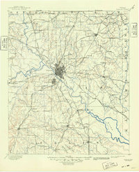
1893 Map of Dallas
USGS Topo · Published 1949About this map
The confluence of the West Fork and Elm Fork defines the landscape of north-central Texas in the late 19th century, centering on the burgeoning city of Dallas. At this time, Oak Cliff and Dallas remain distinct urban centers separated by the river bottoms, while the surrounding prairie is dotted with small, trade-dependent settlements like Eagle Ford, Jim Town, and Haughts Store. The map illustrates a transitional economy where older river crossings like Doddy's Ferry and Barnes Bridge still serve local traffic alongside an expanding network of railroads.
Find a feature on this map
82 named features on this map. Tap any name to fly to it.
Don’t see what you’re looking for? This feature index may not catch every label — zoom into the map to look around manually.
Map Details
Editions of this 1893 Dallas Map
5 editions found
Other maps of this area

1891 · Dallas
USGS Topo · 1:125,000

1891 · Cleburne
USGS Topo · 1:125,000

1893 · Dallas
USGS Topo · 1:125,000

1894 · Cleburne
USGS Topo · 1:125,000

1894 · Fort Worth
USGS Topo · 1:125,000

1912 · Rockwall
USGS Topo · 1:31,680

1919 · Royse City
USGS Topo · 1:62,500

1924 · Farmersville 3-c
USGS Topo · 1:48,000

1924 · Mc Kinney 4-d
USGS Topo · 1:48,000

1925 · Mc Kinney 3-c
USGS Topo · 1:48,000