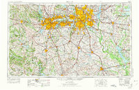
1954 Map of Dallas
USGS Topo · Published 1975About this map
The expanding North Texas urban corridor dominates this regional overview, centered on the growing metropolitan footprint of Dallas and Fort Worth. Compiled in the mid-1950s and updated in the early 1970s, the map illustrates a landscape transitioning from rural agricultural counties to interconnected suburban hubs like Arlington, Irving, and Mesquite. The strategic importance of the Trinity River and the rail legacy of the Texas and Pacific railroad are visible alongside newer infrastructure like Carswell AF Base. Surrounding the urban core, large-scale water management projects such as Lake Ray Hubbard and Cedar Creek Reservoir reshape the local topography. Further west, the terrain rises toward Comanche Peak and Flat Top Mountain, marking the transition from the blackland prairies to the more varied geography of the Brazos River valley.
Find a feature on this map
74 named features on this map. Tap any name to fly to it.
Don’t see what you’re looking for? This feature index may not catch every label — zoom into the map to look around manually.
Map Details
Editions of this 1954 Dallas Map
4 editions found

Other maps of this area

1888 · Hamilton
USGS Topo · 1:125,000

1888 · Meridian
USGS Topo · 1:125,000

1889 · Granbury
USGS Topo · 1:125,000

1890 · Stephenville
USGS Topo · 1:125,000

1891 · Weatherford
USGS Topo · 1:125,000

1891 · Dallas
USGS Topo · 1:125,000

1891 · Palo Pinto
USGS Topo · 1:125,000

1891 · Cleburne
USGS Topo · 1:125,000

1892 · Waco
USGS Topo · 1:125,000

1893 · Dallas
USGS Topo · 1:125,000