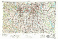
1954 Map of Dallas
USGS Topo · Published 1975About this map
The Trinity River and its major forks anchor the mid-century development of the North Texas plains, illustrating the era of massive post-war urban expansion. While Dallas and Fort Worth remain the primary industrial and cultural hubs, the burgeoning suburbs of Arlington, Irving, and Grand Prairie are clearly defined by the emerging highway network of Interstate 30 and Interstate 20. This survey shows the region's educational and civic footprint through institutions like Southern Methodist University and the Dallas County Courthouse.
Find a feature on this map
303 named features on this map. Tap any name to fly to it.
Don’t see what you’re looking for? This feature index may not catch every label — zoom into the map to look around manually.
Map Details
Editions of this 1954 Dallas Map
4 editions found

Other maps of this area

1888 · Hamilton
USGS Topo · 1:125,000

1888 · Meridian
USGS Topo · 1:125,000

1889 · Granbury
USGS Topo · 1:125,000

1890 · Stephenville
USGS Topo · 1:125,000

1891 · Weatherford
USGS Topo · 1:125,000

1891 · Dallas
USGS Topo · 1:125,000

1891 · Palo Pinto
USGS Topo · 1:125,000

1891 · Cleburne
USGS Topo · 1:125,000

1892 · Waco
USGS Topo · 1:125,000

1893 · Dallas
USGS Topo · 1:125,000