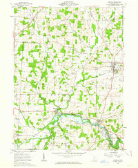
1961 Map of Danville
USGS Topo · Published 1963About this map
The Kokosing River and its major tributaries, Jelloway Creek and Schenck Creek, define the landscape of eastern Knox County in the early 1960s. This survey, conducted just as the Mohawk Dam began controlling seasonal inundation in the valley, shows a region deeply connected by the Pennsylvania railroad line. Small hubs like Danville and Millwood serve as anchors for a rural community marked by numerous country burial grounds, including St Lukes Cem and Workman Cem.
Find a feature on this map
36 named features on this map. Tap any name to fly to it.
Don’t see what you’re looking for? This feature index may not catch every label — zoom into the map to look around manually.
Map Details
Editions of this 1961 Danville Map
3 editions found
Other maps of this area

1912 · Loudonville
USGS Topo · 1:62,500

1912 · Gambier
USGS Topo · 1:62,500

1912 · Perrysville
USGS Topo · 1:62,500

1913 · Brinkhaven
USGS Topo · 1:62,500

1914 · Gambier
USGS Topo · 1:62,500

1914 · Loudonville
USGS Topo · 1:62,500

1915 · Brinkhaven
USGS Topo · 1:62,500

1915 · Perrysville
USGS Topo · 1:62,500

1943 · Gambier
USGS Topo · 1:62,500

1943 · Loudonville
USGS Topo · 1:62,500