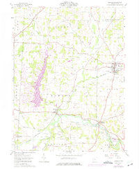
1961 Map of Danville
USGS Topo · Published 1975About this map
The Kokosing River and Penn Central railroad corridor define the economic landscape of this Knox County region during the early 1960s. The village of Danville serves as a primary hub, while smaller centers like Howard and Millwood mark the path of the rail line. Extensive infrastructure for the local energy industry is evident through numerous Gas Wells and Oil Wells scattered across the townships, particularly within the designated Oil Field.
Find a feature on this map
46 named features on this map. Tap any name to fly to it.
Don’t see what you’re looking for? This feature index may not catch every label — zoom into the map to look around manually.
Map Details
Editions of this 1961 Danville Map
3 editions found
Other maps of this area

1912 · Loudonville
USGS Topo · 1:62,500

1912 · Gambier
USGS Topo · 1:62,500

1912 · Perrysville
USGS Topo · 1:62,500

1913 · Brinkhaven
USGS Topo · 1:62,500

1914 · Gambier
USGS Topo · 1:62,500

1914 · Loudonville
USGS Topo · 1:62,500

1915 · Brinkhaven
USGS Topo · 1:62,500

1915 · Perrysville
USGS Topo · 1:62,500

1943 · Gambier
USGS Topo · 1:62,500

1943 · Loudonville
USGS Topo · 1:62,500