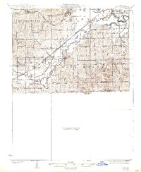
1924 Map of Dawn
USGS Topo · Published 1938About this map
Dawn and Ludlow anchor this rural landscape in Livingston County, where a dense network of one-room schoolhouses served the early 20th-century farming community. The map reveals a high concentration of local educational centers, from Brush College School and Maple Grove School in the north to Stone School and Hosier School near the border with Carroll County. The Grand River and Shoal Creek define the drainage of the region, while the Chicago Burlington and Quincy and St Paul and Milwaukee railroads provided the vital connections for transporting goods and people. Notable landmarks like Blue Mound rise above the surrounding terrain, which is otherwise carved by water bodies such as Rattlesnake Creek and Wolf Creek. This survey captures the height of the rural school system before the mid-century trend of district consolidation.
Find a feature on this map
47 named features on this map. Tap any name to fly to it.
Don’t see what you’re looking for? This feature index may not catch every label — zoom into the map to look around manually.
Map Details
Editions of this 1924 Dawn Map
4 editions found
Other maps of this area

1889 · Lexington
USGS Topo · 1:125,000

1890 · Marshall
USGS Topo · 1:125,000

1892 · Marshall
USGS Topo · 1:125,000

1901 · Marshall
USGS Topo · 1:125,000

1921 · Chillicothe
USGS Topo · 1:62,500

1922 · Gallatin
USGS Topo · 1:62,500

1923 · Chillicothe
USGS Topo · 1:62,500

1924 · Dawn
USGS Topo · 1:62,500

1924 · Braymer
USGS Topo · 1:62,500

1924 · Chula
USGS Topo · 1:62,500