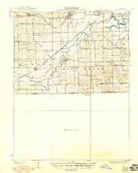
1924 Map of Dawn
USGS Topo · Published 1950About this map
The Grand River and its meandering tributaries, including Shoal Creek and Wolf Creek, define the agricultural landscape of southern Livingston County in this early 20th-century survey. The region is characterized by a dense network of rural infrastructure, featuring two major rail lines: the Chicago Burlington and Quincy and the Chicago Milwaukee and St. Paul. These railroads connect the primary settlements of Mooresville, Utica, and Ludlow, with the community of Dawn serving as a central hub.
Find a feature on this map
46 named features on this map. Tap any name to fly to it.
Don’t see what you’re looking for? This feature index may not catch every label — zoom into the map to look around manually.
Map Details
Editions of this 1924 Dawn Map
4 editions found
Other maps of this area

1889 · Lexington
USGS Topo · 1:125,000

1890 · Marshall
USGS Topo · 1:125,000

1892 · Marshall
USGS Topo · 1:125,000

1901 · Marshall
USGS Topo · 1:125,000

1921 · Chillicothe
USGS Topo · 1:62,500

1922 · Gallatin
USGS Topo · 1:62,500

1923 · Chillicothe
USGS Topo · 1:62,500

1924 · Dawn
USGS Topo · 1:62,500

1924 · Braymer
USGS Topo · 1:62,500

1924 · Chula
USGS Topo · 1:62,500