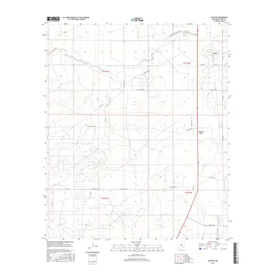
2017 Map of Dayton
USGS Topo · Published 2017About this map
Dayton sits near the eastern edge of this Eddy County landscape, where the Chihuahuan Desert terrain is marked by a complex network of ranch roads and ephemeral watercourses. The northern portion of the quadrangle is defined by the winding path of Rio Peñasco, while the southern reaches are crossed by N Seven Rivers. The settlement of Frontier Post appears along the primary north-south transit corridor, illustrating the modern distribution of small communities in this arid region. The map reveals a land divided into large ranching tracts, evidenced by names like Kincaid Ranch Rd and Skp Ranch Rd. This 2017 survey by the U.S. Geological Survey provides a high-resolution view of the rural infrastructure, from the Pipeline Rd to the various county routes that connect isolated homesteads and ranching operations across the New Mexico plains.
Find a feature on this map
31 named features on this map. Tap any name to fly to it.
Don’t see what you’re looking for? This feature index may not catch every label — zoom into the map to look around manually.
Map Details
Editions of this 2017 Dayton Map
This is the sole edition of this map. No revisions or reprints were ever made.
Other maps of this area

1954 · Seven Rivers
USGS Topo · 1:24,000

1954 · Carlsbad
USGS Topo · 1:250,000

1955 · Artesia
USGS Topo · 1:24,000

1955 · Spring Lake
USGS Topo · 1:24,000

1955 · Dayton
USGS Topo · 1:24,000

1955 · Lake Mc Millan North
USGS Topo · 1:24,000

1955 · Lake Mc Millan South
USGS Topo · 1:24,000

1956 · Parish Ranch
USGS Topo · 1:24,000

1956 · Hope SE
USGS Topo · 1:24,000

1957 · Foster Ranch
USGS Topo · 1:24,000