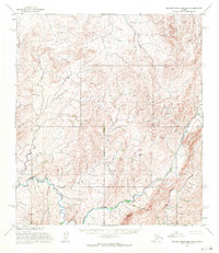
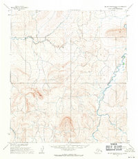
1955 Map of De Long Mountains B-4
USGS Topo · Published 1971About this map
The Kukpuk River defines the lower third of this 1950s terrain study, winding through the southern reaches of the De Long Mountains. This particular quadrangle represents a landscape of pure topography, where the absence of named settlements, roads, or trails emphasizes the primary focus on hydrologic and geological surveying. While the northern and central portions are dominated by dense contour work marking the uplands, the Kukpuk River provides the sole major navigational reference for the entire sheet. Derived from aerial photographs taken between 1952 and 1955, the map preserves the natural state of the North Slope's drainage patterns before modern development or infrastructure reached this part of the Brooks Range foothills. It serves as a specific baseline for understanding the unchanged character of the Alaskan wilderness during the mid-twentieth century.
Find a feature on this map
1 named feature on this map. Tap any name to fly to it.
Don’t see what you’re looking for? This feature index may not catch every label — zoom into the map to look around manually.
Map Details
Editions of this 1955 De Long Mountains B-4 Map
2 editions found
Other maps of this area

1951 · De Long Mountains
USGS Topo · 1:250,000

1955 · De Long Mountains
USGS Topo · 1:250,000

1955 · De Long Mountains A-3
USGS Topo · 1:63,360

1955 · De Long Mountains A-4
USGS Topo · 1:63,360
1955 · De Long Mountains A-5
USGS Topo · 1:63,360

1955 · De Long Mountains C-4
USGS Topo · 1:63,360

1955 · De Long Mountains C-5
USGS Topo · 1:63,360

1955 · De Long Mountains B-3
USGS Topo · 1:63,360
1955 · De Long Mountains B-5
USGS Topo · 1:63,360
1955 · De Long Mountains C-3
USGS Topo · 1:63,360