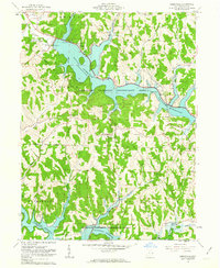
1961 Map of Deersville
USGS Topo · Published 1963About this map
Tappan Reservoir and Clendening Reservoir dominate this eastern Ohio landscape, representing the engineering efforts of the Muskingum Watershed Conservancy District. In the early 1960s, these reservoirs were established fixtures, providing flood control and recreation at Tappan Lake Park and various youth retreats like YMCA Camp and Fort Steuben Camp. The map preserves the transition from industrial extraction to managed conservation, visible where a Strip Mine sits just north of the flooded valleys. Local heritage is deeply rooted in the surrounding hills, where small settlements like Deersville and Minksville remain connected by winding routes past country landmarks such as Mount Hope Ch and Brownsville Ch. A unique cadastral feature is the Dohrman Grant Boundary, reflecting the complex early land surveys of the Old Seven Ranges.
Find a feature on this map
34 named features on this map. Tap any name to fly to it.
Don’t see what you’re looking for? This feature index may not catch every label — zoom into the map to look around manually.
Map Details
Editions of this 1961 Deersville Map
4 editions found
Other maps of this area

1902 · Scio
USGS Topo · 1:62,500

1903 · Flushing
USGS Topo · 1:62,500

1904 · Scio
USGS Topo · 1:62,500

1905 · Flushing
USGS Topo · 1:62,500

1909 · Antrim
USGS Topo · 1:48,000

1909 · Uhrichsville
USGS Topo · 1:62,500

1911 · Antrim
USGS Topo · 1:62,500

1911 · Uhrichsville
USGS Topo · 1:62,500

1951 · Canton
USGS Topo · 1:250,000

1953 · Canton
USGS Topo · 1:250,000