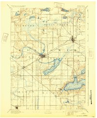
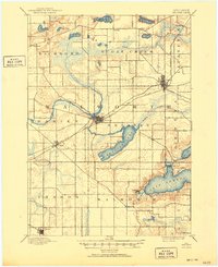
1893 Map of Delavan
USGS Topo · Published 1932About this map
The glacial landscapes of Walworth County are defined here by a series of prominent lakes and developing railway hubs in the late nineteenth century. Lake Geneva anchors the southeast corner, with the village of Williams Bay and the landing at Fontana established along its western shores. Further north, the town of Delavan sits at a critical junction of the Chicago Milwaukee and St. Paul Railroad and the waters of Delavan Lake. The mapping reveals a highly organized township structure, where agricultural land is partitioned around small crossroads communities like Millard, Tibbet, and Fayetteville. The transition from rural creek valleys, such as Sugar Creek and Jackson Creek, to the industrializing rail corridors at Elkhorn illustrates the shift toward the region's role as a dairy and transportation center before the turn of the century.
Find a feature on this map
36 named features on this map. Tap any name to fly to it.
Don’t see what you’re looking for? This feature index may not catch every label — zoom into the map to look around manually.
Map Details
Editions of this 1893 Delavan Map
6 editions found
Other maps of this area

1891 · Koshkonong
USGS Topo · 1:62,500

1892 · Whitewater
USGS Topo · 1:62,500

1892 · Eagle
USGS Topo · 1:62,500

1893 · Delavan
USGS Topo · 1:62,500

1893 · Whitewater
USGS Topo · 1:62,500

1893 · Shopiere
USGS Topo · 1:62,500

1893 · Geneva
USGS Topo · 1:62,500

1894 · Eagle
USGS Topo · 1:62,500

1894 · Koshkonong
USGS Topo · 1:62,500

1897 · Eagle
USGS Topo · 1:62,500