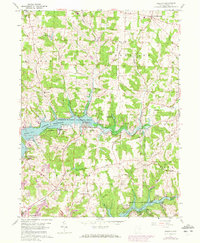
1959 Map of Dellroy
USGS Topo · Published 1972About this map
Dellroy sits at the heart of this landscape, positioned along the winding course of the Indian Fork during a period of significant hydroelectric and conservation activity. The map reveals the sprawling waters of the Atwood Reservoir, managed by the Muskingum Watershed Conservancy District, alongside the Leesville Res to the south. These man-made features altered the traditional valley landscape, which was once dominated by smaller agricultural settlements like Leavittsville and Tabor.
Find a feature on this map
51 named features on this map. Tap any name to fly to it.
Don’t see what you’re looking for? This feature index may not catch every label — zoom into the map to look around manually.
Map Details
Editions of this 1959 Dellroy Map
4 editions found
Other maps of this area

1902 · Scio
USGS Topo · 1:62,500

1904 · Scio
USGS Topo · 1:62,500

1909 · Uhrichsville
USGS Topo · 1:62,500

1910 · Carrollton
USGS Topo · 1:62,500

1911 · Uhrichsville
USGS Topo · 1:62,500

1912 · Dover
USGS Topo · 1:62,500

1912 · Carrollton
USGS Topo · 1:62,500

1944 · Dover
USGS Topo · 1:62,500

1951 · Canton
USGS Topo · 1:250,000

1953 · Canton
USGS Topo · 1:250,000