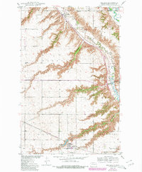
1950 Map of Des Lacs
USGS Topo · Published 1980About this map
Des Lacs and the surrounding Ward County prairie are defined by an intricate network of coulees that drain toward the Souris River and Des Lacs Res. This 1950 survey, photorevised in 1980, shows a landscape of distributed farmsteads and rural infrastructure, including School No 3 and the Town Hall located west of Foxholm. The deep cuts of Tasker Coulee, Lonetree Coulee, and Glick Coulee illustrate the dramatic erosion patterns typical of this region's glacial geography. Transportation is anchored by the Burlington Northern railroad, which follows the natural corridor of the river valley. The map also documents the southern edge of the Upper Souris National Wildlife Refuge, where the river loops through the northeast corner, providing a vital contrast to the surrounding agricultural townships of Wayland, Saint Marys, and Burlington.
Find a feature on this map
28 named features on this map. Tap any name to fly to it.
Don’t see what you’re looking for? This feature index may not catch every label — zoom into the map to look around manually.
Map Details
Editions of this 1950 Des Lacs Map
3 editions found
Other maps of this area

1928 · Minot
USGS Topo · 1:62,500

1948 · Burlington
USGS Topo · 1:24,000

1948 · Burlington
USGS Topo · 1:62,500

1948 · Minot NW
USGS Topo · 1:24,000

1949 · Burlington NW
USGS Topo · 1:24,000

1949 · Minot NW
USGS Topo · 1:24,000

1949 · Carpio NE
USGS Topo · 1:24,000

1949 · Carpio
USGS Topo · 1:24,000

1950 · Des Lacs
USGS Topo · 1:24,000
1950 · Burlington
USGS Topo · 1:24,000