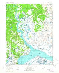
1952 Map of Dillingham A-7
USGS Topo · Published 1963About this map
The confluence of the Wood River and the Nushagak River defines this 1952 topographic record, centered on the settlement of Dillingham. At this time, the community is anchored by Snag Point, with a landing strip providing a critical aerial link to the outside world. To the southwest, the coastal outposts of Kanakanak and Nekapville sit near Bradford Pt, illustrating the shoreline-dependent settlement patterns of Bristol Bay.
Find a feature on this map
20 named features on this map. Tap any name to fly to it.
Don’t see what you’re looking for? This feature index may not catch every label — zoom into the map to look around manually.
Map Details
Editions of this 1952 Dillingham A-7 Map
2 editions found
Other maps of this area

1945 · Nushagak Bay
USGS Topo · 1:250,000

1949 · Nushagak Bay
USGS Topo · 1:250,000

1951 · Dillingham
USGS Topo · 1:250,000

1951 · Nushagak Bay
USGS Topo · 1:250,000

1952 · Dillingham A-8
USGS Topo · 1:63,360

1952 · Dillingham A-6
USGS Topo · 1:63,360

1952 · Nushagak Bay D-1
USGS Topo · 1:63,360

1952 · Dillingham A-7
USGS Topo · 1:63,360
1952 · Nushagak Bay D-2
USGS Topo · 1:63,360

1954 · Dillingham
USGS Topo · 1:250,000