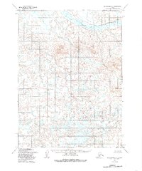
1954 Map of Dillingham C-2
USGS Topo · Published 1985About this map
Stuyahok Hills dominate the northern landscape of this interior Alaska territory, where the topography was first documented using aerial photography from the mid-1950s. The drainage network is defined by the Stuyahok River and its tributary, Yellow Creek, which cut through a complex system of marshes and high ridges. The absence of roads or established trails on this sheet highlights the primitive nature of the terrain during the post-war era, as mapped by the Defense Mapping Agency and the U.S. Geological Survey. This documentation represents a period of systematic geodetic study in the region, relying on photogrammetric methods to chart the elevation contours and water bodies of this remote Alaskan interior.
Find a feature on this map
3 named features on this map. Tap any name to fly to it.
Don’t see what you’re looking for? This feature index may not catch every label — zoom into the map to look around manually.
Map Details
Editions of this 1954 Dillingham C-2 Map
2 editions found
Other maps of this area

1951 · Dillingham
USGS Topo · 1:250,000

1954 · Dillingham
USGS Topo · 1:250,000

1954 · Dillingham C-3
USGS Topo · 1:63,360

1954 · Dillingham D-2
USGS Topo · 1:63,360

1954 · Dillingham C-1
USGS Topo · 1:63,360
1954 · Dillingham B-2
USGS Topo · 1:63,360

1954 · Dillingham B-3
USGS Topo · 1:63,360

1954 · Dillingham D-3
USGS Topo · 1:63,360

1954 · Dillingham C-2
USGS Topo · 1:63,360

1954 · Dillingham D-1
USGS Topo · 1:63,360