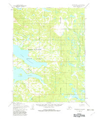
1954 Map of Dillingham C-7
USGS Topo · Published 1982About this map
Wood-Tikchik State Park dominates this mid-century survey, showcasing the intricate glacial lake systems of southwestern Alaska before modern development. Large bodies of water including Lake Beverley, Nerka Lake, and Lake Kulik are connected by short, powerful waterways like the Agelukpak R. The landscape is a network of drainage systems where Moose Creek, Spider Creek, and Hope Creek feed into the larger basins.
Find a feature on this map
20 named features on this map. Tap any name to fly to it.
Don’t see what you’re looking for? This feature index may not catch every label — zoom into the map to look around manually.
Map Details
Editions of this 1954 Dillingham C-7 Map
3 editions found
Other maps of this area

1951 · Dillingham
USGS Topo · 1:250,000

1954 · Dillingham
USGS Topo · 1:250,000

1954 · Dillingham C-6
USGS Topo · 1:63,360

1954 · Dillingham D-6
USGS Topo · 1:63,360

1954 · Dillingham D-7
USGS Topo · 1:63,360

1954 · Dillingham B-7
USGS Topo · 1:63,360

1954 · Dillingham B-8
USGS Topo · 1:63,360

1954 · Dillingham B-6
USGS Topo · 1:63,360

1954 · Dillingham D-8
USGS Topo · 1:63,360

1954 · Dillingham C-7
USGS Topo · 1:63,360