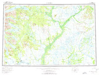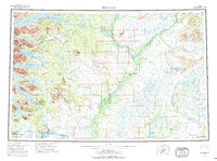
1954 Map of Dillingham
USGS Topo · Published 1995About this map
The Nushagak River and its complex network of tributaries define this mid-century portrait of southwestern Alaska. Centered on the hub of Dillingham, the landscape reveals a series of remote settlements including Kanakanak, Nelsonville, and Ekwok that rely on the waterways for transport and survival. To the west, the formidable Wood River Mountains rise sharply, cradling a chain of massive glacial lakes such as Lake Aleknagik, Lake Nerka, and Lake Beverley. This region, largely encompassed by the Togiak National Wildlife Refuge, shows the early infrastructure of the Bush, featuring the Dillingham Airfield and smaller strips at Koliganek and Aleknagik. The intersection of the Mulchatna River and the Kvichak River systems highlights the importance of these aquatic corridors for the commercial fishing and subsistence cultures of the era.
Find a feature on this map
76 named features on this map. Tap any name to fly to it.
Don’t see what you’re looking for? This feature index may not catch every label — zoom into the map to look around manually.
Map Details
Editions of this 1954 Dillingham Map
3 editions found