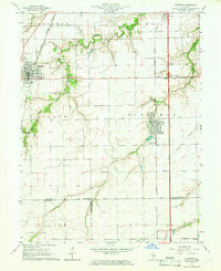
1965 Map of Divernon
USGS Topo · Published 1966About this map
The fertile Sangamon County prairies near Divernon and Auburn appear as a complex network of agriculture and transport in the mid-1960s. This landscape is defined by the winding paths of Sugar Creek and Brush Creek, where wooded corridors contrast with the geometric grid of farmland and township lines. A high concentration of small cemeteries, including Wimmer Cem, Auburn Cem, and Brush Creek Cem, provides significant value for genealogists tracing family histories across Auburn and Divernon townships.
Find a feature on this map
36 named features on this map. Tap any name to fly to it.
Don’t see what you’re looking for? This feature index may not catch every label — zoom into the map to look around manually.
Map Details
Editions of this 1965 Divernon Map
3 editions found
Other maps of this area

1922 · Divernon
USGS Topo · 1:62,500

1923 · Carlinville
USGS Topo · 1:48,000

1923 · Raymond
USGS Topo · 1:62,500

1924 · Divernon
USGS Topo · 1:62,500

1924 · Waverly
USGS Topo · 1:62,500

1925 · Carlinville
USGS Topo · 1:62,500

1925 · Raymond
USGS Topo · 1:62,500

1926 · Waverly
USGS Topo · 1:62,500

1931 · Carlinville
USGS Topo · 1:62,500

1958 · Decatur
USGS Topo · 1:250,000