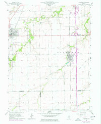
1965 Map of Divernon
USGS Topo · Published 1978About this map
Auburn and Divernon serve as the primary anchors for this mid-1960s landscape, which transitioned into a major transit corridor as the modern interstate system began to reshape Sangamon County. The map documents a diverse rail-and-road economy where traditional infrastructure like the Gulf Mobile and Ohio and Illinois Central railroads intersect with newer developments such as the Brown Landing Strip and Edgewood Country Club. Local history and genealogy are well-represented through numerous family and community landmarks, including the Sugar Creek Ch Cem and the Wimmer Cem. The rural landscape is defined by the winding paths of Sugar Creek and Brush Creek, punctuated by industrial nodes like a Quarry and a Gravel Pit. Small hamlets and junctions, such as Glenarm, Cimic, and Pawnee Junction, remain visible as the region's agricultural character meets the evolving needs of the mid-20th century.
Find a feature on this map
35 named features on this map. Tap any name to fly to it.
Don’t see what you’re looking for? This feature index may not catch every label — zoom into the map to look around manually.
Map Details
Editions of this 1965 Divernon Map
3 editions found
Other maps of this area

1922 · Divernon
USGS Topo · 1:62,500

1923 · Carlinville
USGS Topo · 1:48,000

1923 · Raymond
USGS Topo · 1:62,500

1924 · Divernon
USGS Topo · 1:62,500

1924 · Waverly
USGS Topo · 1:62,500

1925 · Carlinville
USGS Topo · 1:62,500

1925 · Raymond
USGS Topo · 1:62,500

1926 · Waverly
USGS Topo · 1:62,500

1931 · Carlinville
USGS Topo · 1:62,500

1958 · Decatur
USGS Topo · 1:250,000