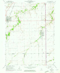
1965 Map of Divernon
USGS Topo · Published 1972About this map
The agrarian landscape of Sangamon County is anchored by the rail junctions and small settlements of Auburn and Divernon in this mid-1960s topographic record. The geography is defined by the winding course of Sugar Creek, which flows northward through the center of the sheet, and the intersecting routes of the Illinois Central, Gulf Mobile and Ohio, and Chicago and Illinois Midland railroads. These rail lines supported local industry, evidenced by the Gravel Pit near the northern boundary and a Quarry just north of Divernon.
Find a feature on this map
31 named features on this map. Tap any name to fly to it.
Don’t see what you’re looking for? This feature index may not catch every label — zoom into the map to look around manually.
Map Details
Editions of this 1965 Divernon Map
3 editions found
Other maps of this area

1922 · Divernon
USGS Topo · 1:62,500

1923 · Carlinville
USGS Topo · 1:48,000

1923 · Raymond
USGS Topo · 1:62,500

1924 · Divernon
USGS Topo · 1:62,500

1924 · Waverly
USGS Topo · 1:62,500

1925 · Carlinville
USGS Topo · 1:62,500

1925 · Raymond
USGS Topo · 1:62,500

1926 · Waverly
USGS Topo · 1:62,500

1931 · Carlinville
USGS Topo · 1:62,500

1958 · Decatur
USGS Topo · 1:250,000