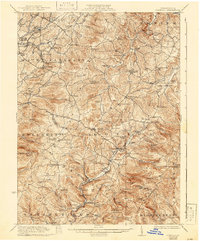
1935 Map of Donegal
USGS Topo · Published 1942About this map
The Lincoln Highway cuts across the center of this landscape, anchoring a network of mountain communities and rural schoolhouses in Westmoreland and Fayette Counties. The terrain is defined by prominent ridges like Spook Hill and Painter Rock Hill, where countless small schools such as Jockey Knob School and Snowball School served isolated family farms. Industrial hubs like Mammoth and Kecksburg are clearly visible, connected by the Pennsylvania RR, while the southern reaches follow Indian Creek through Sagamore and Melcroft along the Baltimore and Ohio RR tracks.
Find a feature on this map
120 named features on this map. Tap any name to fly to it.
Don’t see what you’re looking for? This feature index may not catch every label — zoom into the map to look around manually.
Map Details
Editions of this 1935 Donegal Map
2 editions found

Other maps of this area

1900 · Uniontown
USGS Topo · 1:62,500

1900 · Latrobe
USGS Topo · 1:62,500

1902 · Latrobe
USGS Topo · 1:62,500

1902 · Connellsville
USGS Topo · 1:62,500

1903 · Latrobe
USGS Topo · 1:62,500

1904 · Greensburg
USGS Topo · 1:62,500

1906 · Greensburg
USGS Topo · 1:62,500

1913 · Somerset
USGS Topo · 1:62,500

1915 · Somerset
USGS Topo · 1:62,500

1920 · New Florence
USGS Topo · 1:62,500