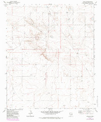
1972 Map of Dora SW
USGS Topo · Published 1985About this map
Industrial activity and resource extraction define this landscape in Roosevelt County during the early 1970s. The terrain is marked by a network of exploration and utility infrastructure, including a prominent Pipeline that cuts across the northern sections of the township. This period of development is evidenced by the numerous Drill Holes and an Oil Well scattered throughout the quadrangle, indicating a focused search for subterranean resources. Benchmark markers such as Wm 4358 and Wm 4401 provide precise topographic reference points across the undulating surface. The map also captures fine-scale agricultural boundaries, noted as selected fence lines, which delineate the rural land use alongside the emerging energy infrastructure. This document serves as a detailed record of the intersections between livestock ranching and the petroleum industry in eastern New Mexico.
Find a feature on this map
13 named features on this map. Tap any name to fly to it.
Don’t see what you’re looking for? This feature index may not catch every label — zoom into the map to look around manually.
Map Details
Editions of this 1972 Dora SW Map
2 editions found
Other maps of this area

1954 · Brownfield
USGS Topo · 1:250,000

1958 · Brownfield
USGS Topo · 1:250,000

1962 · Brownfield
USGS Topo · 1:250,000

1972 · Dora NW
USGS Topo · 1:24,000

1972 · Milnesand
USGS Topo · 1:24,000

1972 · Dora SW
USGS Topo · 1:24,000
1972 · Pep
USGS Topo · 1:24,000
1972 · Milnesand NW
USGS Topo · 1:24,000

1972 · Dora
USGS Topo · 1:24,000
1979 · Badger Lake
USGS Topo · 1:24,000