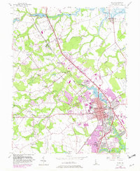
1956 Map of Dover
USGS Topo · Published 1982About this map
Dover serves as the focal point of this mid-century landscape, showing the Delaware state capital during a period of significant suburban expansion and institutional development. The map details the civic core, including the State Capitol, Legislative Hall, and Capitol Green, alongside educational landmarks like Wesley Jr College and State College. Outside the city center, the terrain is defined by a series of residential and rural settlements such as Cheswold, Rodney Village, and Capitol Park. The transportation network is anchored by Dupont Boulevard and the Conrail line, which facilitate movement between the agricultural lands and the growing urban area. Waterways like the Leipsic River and Silver Lake provide a natural framework for the region's development, while smaller locales like Bishops Corner and Moores Corner mark the rural intersections that have long characterized Kent County.
Find a feature on this map
72 named features on this map. Tap any name to fly to it.
Don’t see what you’re looking for? This feature index may not catch every label — zoom into the map to look around manually.
Map Details
Editions of this 1956 Dover Map
3 editions found
Other maps of this area

1890 · Bay Side
USGS Topo · 1:62,500

1894 · Bay Side
USGS Topo · 1:62,500

1899 · Vineland
USGS Topo · 1:125,000

1899 · Dover
USGS Topo · 1:125,000

1906 · Dover
USGS Topo · 1:125,000

1919 · Vineland
USGS Topo · 1:125,000

1920 · Dover
USGS Topo · 1:125,000

1926 · Wyoming
USGS Topo · 1:48,000

1930 · Wyoming
USGS Topo · 1:62,500

1931 · Wyoming
USGS Topo · 1:62,500