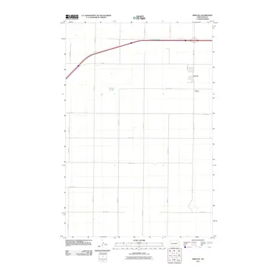
2011 Map of Driscoll
USGS Topo · Published 2011About this map
Driscoll serves as the primary hub in this prairie landscape, where the rectilinear grid of Burleigh County meets the vital transport corridor of Hwy-10. The settlement is defined by a traditional small-town layout, including Park Ave and its proximity to the Driscoll Cemetery. This 2011 survey reveals the subtle hydrography of the region, specifically Cottonwood Lake and the interestingly named Random Slough, both of which are characteristic of the pothole-strewn North Dakota plains. The map traces a network of secondary routes like 57th Ave NE and 340th St NE, which connect isolated farmsteads across the township. For the local researcher, the placement of the cemetery and the specific road names offer a precise record of the modern rural infrastructure and land use in this section of the state.
Find a feature on this map
24 named features on this map. Tap any name to fly to it.
Don’t see what you’re looking for? This feature index may not catch every label — zoom into the map to look around manually.
Map Details
Editions of this 2011 Driscoll Map
This is the sole edition of this map. No revisions or reprints were ever made.
Other maps of this area

1951 · McKenzie
USGS Topo · 1:62,500

1951 · Driscoll
USGS Topo · 1:62,500

1954 · Bismarck
USGS Topo · 1:250,000

1958 · Bismarck
USGS Topo · 1:250,000

1971 · Moffit
USGS Topo · 1:24,000

1975 · Sibley Butte
USGS Topo · 1:24,000

1975 · Sterling
USGS Topo · 1:24,000

1975 · Lake Geneva
USGS Topo · 1:24,000
1975 · Stony Slough
USGS Topo · 1:24,000
1975 · Clear Lake
USGS Topo · 1:24,000