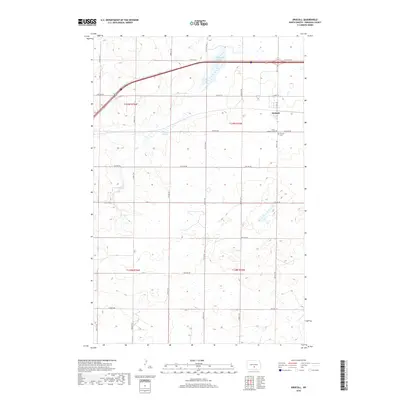
2018 Map of Driscoll
USGS Topo · Published 2018About this map
Driscoll sits at the intersection of a rigid grid of section lines and modern transit corridors in this Burleigh County landscape. The settlement is centered around Main St and Co Hwy 10, reflecting the organized expansion of North Dakota's agricultural heartland. To the west of the town center, Random Slough and Cottonwood Lake break the rectilinear pattern of the township and range system, providing essential water sources in an otherwise dry prairie environment. For those tracing family histories in the area, the map preserves the locations of the Grace Lutheran Cem and the Driscoll Cem, positioned just outside the main residential cluster. This survey illustrates how the landscape is segmented into townships such as t139n r75w, where the prairie is defined by numbered avenues and streets like 57th Ave NE and 405th St NE.
Find a feature on this map
31 named features on this map. Tap any name to fly to it.
Don’t see what you’re looking for? This feature index may not catch every label — zoom into the map to look around manually.
Map Details
Editions of this 2018 Driscoll Map
This is the sole edition of this map. No revisions or reprints were ever made.
Other maps of this area

1951 · McKenzie
USGS Topo · 1:62,500

1951 · Driscoll
USGS Topo · 1:62,500

1954 · Bismarck
USGS Topo · 1:250,000

1958 · Bismarck
USGS Topo · 1:250,000

1971 · Moffit
USGS Topo · 1:24,000

1975 · Sibley Butte
USGS Topo · 1:24,000

1975 · Sterling
USGS Topo · 1:24,000

1975 · Lake Geneva
USGS Topo · 1:24,000
1975 · Stony Slough
USGS Topo · 1:24,000
1975 · Clear Lake
USGS Topo · 1:24,000