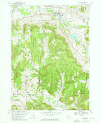
1969 Map of Dryden
USGS Topo · Published 1972About this map
The village of Dryden anchors this late 1960s study of the Tompkins County landscape, where the valley floors are defined by the winding paths of Virgil Creek and the Lehigh Valley corridor. Steep hillsides separate the more developed northern flats from the high-elevation woods of Yellow Barn State Forest and Hammond Hill State Forest. This period shows the transition of rural life, with legacy sites like Dutch Reformed Cem and St Thomas Ch standing alongside modern additions like the Drive-in Theater near Willow Glen.
Find a feature on this map
51 named features on this map. Tap any name to fly to it.
Don’t see what you’re looking for? This feature index may not catch every label — zoom into the map to look around manually.
Map Details
Editions of this 1969 Dryden Map
3 editions found
Other maps of this area

1898 · Moravia
USGS Topo · 1:62,500

1900 · Dryden
USGS Topo · 1:62,500

1902 · Moravia
USGS Topo · 1:62,500

1903 · Cortland
USGS Topo · 1:62,500

1903 · Harford
USGS Topo · 1:62,500

1906 · Catatonk
USGS Topo · 1:125,000

1942 · Groton
USGS Topo · 1:24,000

1943 · West Groton
USGS Topo · 1:31,680

1943 · Groton
USGS Topo · 1:31,680

1944 · Cortland
USGS Topo · 1:31,680