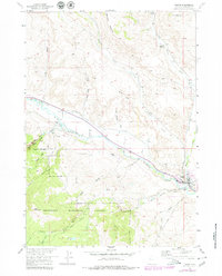
1956 Map of Dubois
USGS Topo · Published 1980About this map
The Dubois townsite serves as the focal point of this survey, positioned where the Wind River carves through the high desert of the Upper Wind River Valley. The settlement's connection to the surrounding ranching and wilderness landscape is evident through features like the Dubois Airport and an older Landing Field (Aband). Local water management is a central theme, with the Holmes No 1 Ditch and Green Ditch cutting across the terrain north of the river, while the southern reaches rise into the Shoshone National Forest. This southern timbered section is marked by a network of paths including the Jake Creek Trail and various jeep trails leading toward Bald Mountain. North of the valley, geological landmarks such as Battrum Mountain and Chimney Rock overlook established homesteads like Shipley Ranch and Harrison Ranch.
Find a feature on this map
36 named features on this map. Tap any name to fly to it.
Don’t see what you’re looking for? This feature index may not catch every label — zoom into the map to look around manually.
Map Details
Editions of this 1956 Dubois Map
4 editions found
Other maps of this area

1905 · Younts Peak
USGS Topo · 1:125,000

1907 · Younts Peak
USGS Topo · 1:125,000

1909 · Fremont Peak
USGS Topo · 1:125,000

1955 · Thermopolis
USGS Topo · 1:250,000

1956 · Indian Point
USGS Topo · 1:24,000

1956 · Dubois
USGS Topo · 1:24,000

1956 · Esmond Park
USGS Topo · 1:24,000

1956 · Ramshorn Peak
USGS Topo · 1:24,000

1956 · Warm Spring Mountain
USGS Topo · 1:24,000

1956 · Mason Draw
USGS Topo · 1:24,000