
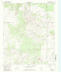
1968 Map of Dumont
USGS Topo · Published 1970About this map
Dumont sits as a central settlement in this West Texas landscape, where the confluence of several seasonal watercourses defines the local geography. The area is characterized by the North Wichita River and its numerous tributaries, including Middle Creek, Eighteen Creek, and Hollar Creek. This survey captures a rural ranching economy dependent on subterranean water sources, evidenced by the high density of named windmills such as the Thief Hollow Windmill, Headquarters Windmill, and McDuff Windmill. These points of infrastructure were vital for livestock and human survival in the arid terrain north of the Shinnery Draw. The map also records early water management efforts with the Dumont Dam and specialized landmarks like Shinnery Springs, providing a detailed look at how land was utilized and subdivided by fence lines across the county borders of Motley, Dickens, Cottle, and King.
Find a feature on this map
30 named features on this map. Tap any name to fly to it.
Don’t see what you’re looking for? This feature index may not catch every label — zoom into the map to look around manually.
Map Details
Editions of this 1968 Dumont Map
2 editions found
Other maps of this area

1954 · Lubbock
USGS Topo · 1:250,000

1967 · Guthrie NW
USGS Topo · 1:24,000

1968 · East Afton
USGS Topo · 1:24,000

1968 · Buffalo Creek
USGS Topo · 1:24,000

1968 · Russellville
USGS Topo · 1:24,000

1968 · Grow NW
USGS Topo · 1:24,000

1968 · China Canyon
USGS Topo · 1:24,000

1968 · East Afton NE
USGS Topo · 1:24,000

1968 · Sanders Hollow
USGS Topo · 1:24,000

1985 · Dickens
USGS Topo · 1:100,000