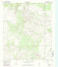
1968 Map of Dumont
USGS Topo · Published 1981About this map
Dumont sits at the meeting point of four Texas counties, serving as a remote outpost where the North Wichita River and Wichita River converge. This 1968 survey, with later revisions, documents a ranching landscape defined by an extensive network of water infrastructure. Named landmarks like the Headquarters Windmill, Dumont Horse Pasture Windmill, and Threeway Windmill indicate the vital importance of groundwater management in this arid territory near the Motley and Dickens county lines.
Find a feature on this map
32 named features on this map. Tap any name to fly to it.
Don’t see what you’re looking for? This feature index may not catch every label — zoom into the map to look around manually.
Map Details
Editions of this 1968 Dumont Map
2 editions found
Other maps of this area

1954 · Lubbock
USGS Topo · 1:250,000

1967 · Guthrie NW
USGS Topo · 1:24,000

1968 · East Afton
USGS Topo · 1:24,000

1968 · Buffalo Creek
USGS Topo · 1:24,000

1968 · Russellville
USGS Topo · 1:24,000

1968 · Grow NW
USGS Topo · 1:24,000

1968 · Dumont
USGS Topo · 1:24,000

1968 · China Canyon
USGS Topo · 1:24,000

1968 · East Afton NE
USGS Topo · 1:24,000

1968 · Sanders Hollow
USGS Topo · 1:24,000