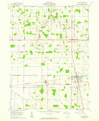
1961 Map of Dunkirk
USGS Topo · Published 1962About this map
The agricultural landscape of Hancock and Hardin counties is defined by a dense network of water management features and rail infrastructure in the early 1960s. Dunkirk serves as the primary hub, situated at the strategic crossing of the Pennsylvania and New York Central railroads. This rail junction supported the surrounding farming communities, including the smaller settlements of Dola, Williamstown, and New Stark.
Find a feature on this map
28 named features on this map. Tap any name to fly to it.
Don’t see what you’re looking for? This feature index may not catch every label — zoom into the map to look around manually.
Map Details
Editions of this 1961 Dunkirk Map
2 editions found
Other maps of this area

1905 · Arlington
USGS Topo · 1:62,500

1907 · Bluffton
USGS Topo · 1:62,500

1907 · Arlington
USGS Topo · 1:24,000

1913 · Alger
USGS Topo · 1:48,000

1915 · Alger
USGS Topo · 1:62,500

1915 · Kenton
USGS Topo · 1:62,500

1943 · Alger
USGS Topo · 1:62,500

1944 · Kenton
USGS Topo · 1:62,500

1950 · Marion
USGS Topo · 1:250,000

1960 · Rawson
USGS Topo · 1:24,000