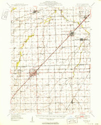
1950 Map of Dwight
USGS Topo · Published 1950About this map
Dwight and its surrounding prairie communities are captured during a mid-century period of agricultural and industrial stability. The landscape is defined by a dense network of country schools like Goodfarm Sch and Stamm Sch, alongside legacy coal mining infrastructure evidenced by several Mine Dumps near South Wilmington and Braceville. A notable landmark of social history is the State Reformatory for Women situated just west of Dwight. Transport and commerce are anchored by the intersection of major rail lines, including the Gulf Mobile and Ohio and the Atchison Topeka and Santa Fe. This survey reveals a highly organized rural society where every township section is serviced by named schools and family cemeteries like Wheeler Cem, reflecting the deep-rooted settlement patterns of Grundy Co and Livingston Co.
Find a feature on this map
72 named features on this map. Tap any name to fly to it.
Don’t see what you’re looking for? This feature index may not catch every label — zoom into the map to look around manually.
Map Details
Editions of this 1950 Dwight Map
2 editions found

Other maps of this area

1892 · Morris
USGS Topo · 1:62,500

1892 · Marseilles
USGS Topo · 1:62,500

1892 · Wilmington
USGS Topo · 1:62,500

1916 · Marseilles
USGS Topo · 1:62,500

1918 · Wilmington
USGS Topo · 1:62,500

1918 · Morris
USGS Topo · 1:62,500

1923 · Herscher
USGS Topo · 1:62,500

1925 · Herscher
USGS Topo · 1:62,500

1935 · Pontiac
USGS Topo · 1:62,500

1939 · Pontiac
USGS Topo · 1:62,500