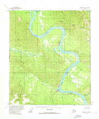
1956 Map of Eagle D-1
USGS Topo · Published 1972About this map
The Yukon River carves a massive path through this subarctic interior landscape, where the international border with Canada meets the American wilderness. The historic settlement of Eagle and nearby Eagle Village sit along the southern banks, serving as critical points of human presence in this high-latitude terrain. Transport and infrastructure are represented by the Taylor Highway, which terminates near the river, and the Eagle Landing Strip, indicating the area's reliance on air and river travel. Distinctive geological markers like the striped Calico Bluff and the prominent Eagle Bluff overlook the water, while the Seventymile River and Tatonduk River feed the Yukon's flow. Traces of early mobility appear in the form of a Tractor Trail cutting through the valleys of Mission Creek and Excelsior Creek, reflecting a time of rugged overland transit.
Find a feature on this map
36 named features on this map. Tap any name to fly to it.
Don’t see what you’re looking for? This feature index may not catch every label — zoom into the map to look around manually.
Map Details
Editions of this 1956 Eagle D-1 Map
3 editions found
Other maps of this area

1899 · Fortymile
USGS Topo · 1:250,000

1951 · Charley River
USGS Topo · 1:250,000

1951 · Eagle
USGS Topo · 1:250,000

1956 · Charley River A-2
USGS Topo · 1:63,360

1956 · Charley River A-1
USGS Topo · 1:63,360

1956 · Charley River
USGS Topo · 1:250,000

1956 · Eagle C-1
USGS Topo · 1:63,360

1956 · Eagle D-2
USGS Topo · 1:63,360

1956 · Eagle C-2
USGS Topo · 1:63,360
1956 · Eagle D-1
USGS Topo · 1:63,360