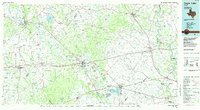
1985 Map of Eagle Lake
USGS Topo · Published 1985About this map
Stephen F Austin State Park and the winding Colorado River corridor define the landscape of this 1985 planimetric study, which covers a significant portion of South Central Texas across Colorado, Fayette, Austin, and Waller counties. The map documents an era of extensive energy extraction, characterized by the Columbus Oil Field, Frelsburg Oil Field, and the Raccoon Bend Oil Field. Transportation networks are dominated by major rail lines including the Missouri - Kansas - Texas Railroad and the Southern Pacific Railroad, while an Old Railroad Grade near San Felipe hints at earlier transit patterns.
Find a feature on this map
158 named features on this map. Tap any name to fly to it.
Don’t see what you’re looking for? This feature index may not catch every label — zoom into the map to look around manually.
Map Details
Editions of this 1985 Eagle Lake Map
2 editions found
Other maps of this area

1885 · Bastrop
USGS Topo · 1:125,000

1893 · Bastrop
USGS Topo · 1:125,000

1901 · Flatonia
USGS Topo · 1:125,000

1904 · Bastrop
USGS Topo · 1:125,000

1919 · Fayettsville
USGS Topo · 1:62,500

1919 · Giddings
USGS Topo · 1:62,500

1919 · Schulenburg
USGS Topo · 1:62,500

1920 · Waller
USGS Topo · 1:31,680

1930 · Brenham
USGS Topo · 1:62,500

1948 · Smithville
USGS Topo · 1:62,500