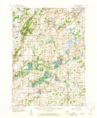
1960 Map of Eagle
USGS Topo · Published 1962About this map
Kettle Moraine topography dominates the western edge of this landscape, where a series of glacial lakes and wetlands transition into the agricultural plains of the Fox River valley. The map documents a cluster of mid-century communities including Mukwonago, East Troy, and North Prairie, many of which were established as vital stops along the Chicago Milwaukee St Paul and Pacific railroad. The presence of specialized institutions like the Divine Word Seminary and the Boys Camp near Phantom Lake suggests the area's role as both a spiritual and recreational destination for the region. Significant industrial activity is evident in the numerous Gravel Pits and Quarries scattered throughout the northern sections, while local education is anchored by rural landmarks such as Palestine Sch and Beulah Sch.
Find a feature on this map
90 named features on this map. Tap any name to fly to it.
Don’t see what you’re looking for? This feature index may not catch every label — zoom into the map to look around manually.
Map Details
Editions of this 1960 Eagle Map
3 editions found
Other maps of this area

1891 · Muskego
USGS Topo · 1:62,500

1892 · Waukesha
USGS Topo · 1:62,500

1892 · Watertown
USGS Topo · 1:62,500

1892 · Oconomowoc
USGS Topo · 1:62,500

1892 · Whitewater
USGS Topo · 1:62,500

1892 · Eagle
USGS Topo · 1:62,500

1893 · Delavan
USGS Topo · 1:62,500

1893 · Whitewater
USGS Topo · 1:62,500

1893 · Silver Lake
USGS Topo · 1:62,500

1893 · Geneva
USGS Topo · 1:62,500