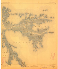
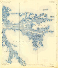
1893 Map of East Delta
USGS Topo · Published 1911About this map
The dynamic Mississippi River delta reaches into the Gulf of Mexico on this survey based on late nineteenth-century field work. The settlement of Balize sits deep within the marshy network of distributaries, while Port Eads guards the mouth of South Pass at the very edge of the continent. Navigational infrastructure is prominent throughout the delta, including the Pass A Loutre Light, the South Pass Light, and a Revenue Station. Unique geomorphological features like the North Pass Mud Lumps and South Mud Lumps indicate the constant shift of silt and sediment at the river's mouth. Cultural remnants like the Old Spanish Magazine suggest the deeper colonial history of the Plaquemines region. Maritime activity is further evidenced by a system of jetties, including the East Jetty and West Jetty, designed to maintain deep channels through the evolving passes for international shipping.
Find a feature on this map
50 named features on this map. Tap any name to fly to it.
Don’t see what you’re looking for? This feature index may not catch every label — zoom into the map to look around manually.
Map Details
Editions of this 1893 East Delta Map
6 editions found
Other maps of this area

1893 · East Delta
USGS Topo · 1:62,500

1893 · Forts
USGS Topo · 1:62,500

1893 · West Delta
USGS Topo · 1:62,500

1935 · Garden Island Pass
USGS Topo · 1:31,680

1935 · South Pass
USGS Topo · 1:31,680

1946 · Mudpan Bayou
USGS Topo · 1:31,680

1947 · Garden Island Pass
USGS Topo · 1:31,680

1947 · Pass A Loutre West
USGS Topo · 1:31,680

1947 · Venice
USGS Topo · 1:31,680

1947 · Southwest Pass
USGS Topo · 1:31,680